M5 Borgata Signora
Departure/arrival location: Festiona (Centro Fondo)
Difficulty: Climb: MC Descent: BC+ Exposure: E2
Length: 16.4 km
Drop + : 610 m
Departure altitude: 715 m asl.
Maximum altitude: 1245 m asl.
Terrain type: 60% Gravel 40% asphalt
Type of route: Ring route, passing through Borgata Coime, Borgata Signora, Madonna della Consolata, Borgata Fiandin, Festiona, Borgata Brocci, Borgata Soprana, Borgata Sottana, Borgata Rueita.
Cartography: Fraternali Map 1: 25000 MTB \ E-Bike Valle Stura di Demonte
DESCRIPTION
From the square in front of Centro Fondo Festiona, we take the path on the paved road called “Ex Militare” towards Demonte\Vinadio, at the intersection toward Demonte\Vinadio we have a road on the left that indicates Borgata Coime, we take it and cycle up to Borgata Coime where on the left we take a gravel road that will take us uphill towards Borgata Signora, passed the hamlet, we go up to the intersection with the panoramic M3 where we will turn left and descend a couple of hairpin bends downstream. Continuing on this road we arrive at the detour to take left towards Madonna della Consolata, after passing the chapel, continue straight towards the votive pylon on the square and behind this we take a descending trail that will turn into a mule track.
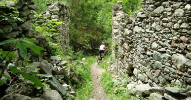
From here, descending, we will reach the pine forest where we find the intersection with M2 route so at this point M2 and M5 become the same route, always descending on a mule track called “Delle Merane”, also a didactic nature trail called “Il bosco”.
At the end of the mule track we cross a paved road that leads us to Borgata Brocc then further to Borgata Soprana, where, crossing the latter, we take the gravel road on the right with changes in slope but with regular terrain. At the end, we go down towards the military road from where we cross the villages of Sottana and Rueita to reach the Centro Fondo Festiona again.
All the paths are frequented by hikers on foot, pay attention especially on descents: THE PEDESTRIAN ALWAYS HAS THE RIGHT OF WAY.


