M2 Percorso dei Castagni
- Departure/arrival location: Festiona (Centro Fondo)
- Difficulty: Climb:MC Descent: MC Exposure:
- Length:
- Drop + : 1050 m
- Departure altitude: 715 m asl
- Maximum altitude: 740 m asl
- Terrain type: 50% Gravel/Military road 50% Asphalt
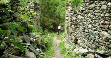
- Type of route: Ring route. We use a stretch of paved road and parts of the local road in the chestnut wood with regular terrain, therefore not particularly demanding.
- Cartography: Fraternali Map 1: 25000 n° 14, Media-Bassa Valle Stura, MTB Map
DESCRIPTION
From Centro Fondo Festiona we start on a paved road and head towards the inhabited area of Festiona, at the first crossroads we keep right continuing on the military road until the detour in the Pilun d’Sant’Anna region, from there we turn to left to continue on the mule track and keeping left at the marked detour we will arrive at Borgata Fiandin. From here we go up on mule track passing near a tank for the collection of water built in military period, continuing the climb up to a pine forest from where, on the left, we descend on a mule track called “Delle Merane”, also known as didactic nature trail called “Il bosco”.
At the end of the mule track we cross a paved road that leads us to the Borgata Brocc then further to Borgata Soprana where, after crossing the latter, we take the gravel road on the right with changes in slope but with regular terrain. At the end, we go down towards the ex-military road from where we cross the villages of Sottana and Rueita to reach Centro Fondo Festiona again.


